PCT photos

I have been home for just over a month now, and finally finished going through the 2,300 photos I took of the PCT on my camera. It was impossible to condense the trail down to the top 100ish photos, since 2,650 miles holds a lot of beauty that can’t be captured in so few scenes. Therefore, I have divided my trip into 4 sections: SoCal, NorCal, Oregon, and Washington. In each of the albums below, you can find 60-150 photos from each of these sections. I hope you enjoy them.
And for those of you who are really into looking at someone else’s photos: here are the best of my PCT photos. Beware: there are 775 photos to look at in this album. It contains all of the pictures in the four sections above, as well as some additional photos that I liked.
Thanks again for following me on my travels and enjoy reliving these moments.
Best,
Lisa (Epic!)
Categories: Uncategorized | 1 Comment

Canada!

From where I camped at Woody pass, it was only 11 miles to the US-Canada border and it was all down hill. I made great time, watching the rocks change color as the sun rose.

image

image

image

At 10 am on August 8, four months and five days after I started, I reached the northern terminus of the Pacific Crest Trail!

image

image

image

image

It was day 128 for me. I had spent 106 days hiking and took 22 days off the trail ( mostly to hang out with Jacob). Many people take five months to complete the PCT, so I’ll consider my 4 months and 5 days as pretty good for a long-distance newbie.
It was cool but sunny and I had the place to myself. I read all of the entries on the trail register and added my own. As far as I can tell, I am the first woman to complete the trail this season, which added to my excitement.
Reading the messages that my trail friends left and seeing when they finished recalled them to my mind and brought back many memories.
I have achieved a life time goal, and feel so good and proud of myself. It was a long journey, with a lot of ups and downs (both literally and figuratively) but I rose above the hardships and finished.

image

Even though I was at the monument, I wasn’t actually done: I still had to get to civilization. So after an hour of hanging out, I packed up and hiked the last 8 miles to Manning Park. I had one more hill to crest and many down trees to climb over, but all of that was easy by comparison.
Now I’m in Manning Park, where soon I will get a drink to celebrate my accomplishments. Tomorrow I’ll take the bus to Vancouver, BC and Tuesday afternoon I will be home!
Thank you to everyone who has shared this adventure with me. I appreciate your reading this and apologize if the prose has not been great. I have typed everything with my thumbs, often late in the day after hiking many miles. I hope the pictures make up for the text.
In the coming weeks I will go through the pictures on my actual camera and will upload an album of the “best of Epic’s PCT adventures 2015” so stay tuned for that!

Categories: PCT adventures | 5 Comments

Getting close

On my penultimate day on the trail it was cold in the morning and there was fog all around. I was bummed that I might miss some views, but as I switchbacked up a hill side, I got above the clouds and everything changed.

image

image

It was like being in an airplane, looking down on the clouds. Above me the sky was blue and it was going to be a perfect day.

image

All I could think about was how close I was getting and how far I had come. I reflected on so many moment in the past four months and tried to relive my journey in my mind. So many things had happened and so many places visited. I was glad to be almost done because I miss Jacob terribly, but I was also sad to know that was my last night camping under the stars. Every mile was bittersweet.

image

At Harts pass I was less than 35 miles away from Canada! It was an appropriately named passed for I saw many deer around it.

image

image

image

I only saw a few people that day but enjoyed the solitude. I went over several passes and decided to camp at Woody Pass thinking I could find a protected spot. Alas, there were few trees at Woody Pass and I was exposed to the wind until it died down with the sun set. I watched the sky light up with stars and thought of my favorite moments on the trail.

Categories: PCT adventures | Leave a comment

Passes

After breaking camp at Bridge Creek, I climbed uphill to Rainy Pass. There were a few low clouds, but blue sky above and it looked like the storm had moved through.

image

After Rainy Pass, I continued the 2500′ climb up to Cutthroat pass, where I stopped for a break. The view was, once again, stunning and I soaked in the sunshine and peacefulness.

image

image

From there, I contoured around the side of several mountains and with each turn I was greeted by even more amazing sights.

image

image

image

Everywhere I looked was another U-shaped valley with peaks rising on all sides. You could easily imagine the glaciers carving their way through the area. Not since the Sierras had I seen anything so spectacular. My breath was taken away every other moment. It was like a part of heaven.

image

image

Eventually I stopped contouring and dropped 2500′ to a valley floor. But of course there’s no flat places in Washington and I almost immediately started up another mountainside.

image

I stopped hiking after 24 miles because according to my maps there weren’t any campsites for another 10 miles and I didn’t want to get stuck on a narrow ridge in the dark. I camped by myself at Glacier Pass and enjoyed the hours of daylight left that day. I was at mile 2610 and had fewer than 50 miles to go! I would be done in less than two days!

Categories: PCT adventures | Leave a comment

More rain

I had a leisurely morning in Stehekin because I had to wait for the post office to open at 10 am to get my packages. I watched the fire fighters some more and wandered around. At 10, I went to the post office where I got two of my three boxes. I had ordered a 5th and final pair of shoes for the last 80 miles but they were not there. The postman suggested I look on the dock and sure enough, the box was there! It had sat on the dock over night and no one touched it.
I repacked my food and put on my new shoes, then waited for the bus to arrive to take me back to the trail.

image

On the ride, the bus stopped at the Stehekin Bakery, where Horizon had sent me a present! It was a $10 gift certificate! I got a famous cinnamon roll and a pesto mushroom croissant. They were both delicious.
I started hiking at 1 pm and headed up hill for a while. The sky became more overcast as the afternoon wore on and by 3 pm it was raining. It rained all afternoon but I was in the cover of trees and didn’t miss too much.
I had a few river crossings, including one a bridge like this.

image

image

It reminded me of Indiana Jones and the temple of Doom.
The trail was pretty much all uphill for the 17 miles I hiked that day and the rain made it chilly. I camped just outside of North Cascades National Park at a beautiful campsite on Bridge Creek. It had stopped raining when I got to camp, but during the night it sprinkled a bit and I was glad to be warm and dry in my tent. I camped at mile 2586.2; less than 70 miles to go!

Categories: PCT adventures | Leave a comment

Agnes Creek

On August 4, I awoke early and was on the trail by 5:45 am. I had a few pleasant, flat miles to walk along the  Suittle River, among an old growth forest. The trees, some of which are over 1,000 years old, towered above me and I could not see their tops. I was a warm and peaceful morning which made me glad to be alive and healthy.
In a few miles I came to a large steel and wooden bridge and crossed to the other side. There was a trail junction and notices about the fire closure posted near by. It was suggested that all hikers take the trail right miles to a parking lot and try to hitch a ride to Rainy pass. By doing this, one would miss nearly 40 miles of the PCT even though only 15 miles were closed. I determined to hike as much of the PCT as possible so I continued up the trail, even if I had to back track later. The trail was closed at a pass and I wanted to get a view of what I would be missing.
After three hours of climbing, I reached the trail closure and looked out. I saw no evidence of fire; I could neither see nor smell smoke.
I reasoned that even if the trail was closed, the wilderness area was still open so I decided to explore a bit more, telling myself that I would turn around at the first sign of danger.
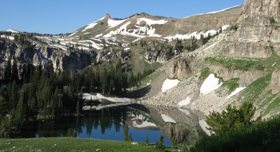
I made my way down the first valley and was greeted with spectacular views.

image

image

The sky was blue, with just a few wisps of clouds, a perfect day. All down that valley and the next one, I kept on the alert for fire but didn’t sense anything. When I got to the valley floor, I crossed Agnes Creek on a log bridge and followed the river for several miles.
Through the trees, on the other side of the river, I started to see a bit of smoke and smelled fire. It was far away and no threat, but I stayed on my guard. As I drew nearer, there was more smoke but it was isolated in just a few places. This is what it looked like at the worst, and most of that was caused by a slight breeze moving the smoke.

image

In another mile I was past the fire and didn’t smell any more smoke. Sure, I had taken a calculated risk, but everything had worked out and I got to see an amazing valley and bowl that most other hikers will miss this season.
When I got out of the closed area I took a break and checked where I was. I had 5 miles to High Bridge, where I could catch a bus into the town of Stehekin, my last resupply point. The last bus came in two hours. It was all down hill. I made up my mind, packed up my stuff, and hiked as quickly as possible. I entered North Cascades National Park along the way, but was mostly in a heavy forest without many views, except for those of the river.

image

image

I walked at nearly 4 miles an hour for five miles and had plenty of time to spare before the red bus came.

image

The ride into town took 45 minutes along the 11 mile dirt road. When we reached the shores of Lake Chelan, where Stehekin lies, I was struck by the wild fire raging on the hillside across the lake.

image

I could see trees on fire and two helicopters dropping water on the fire. I watched this spectacle for an hour while I ate dinner, then got on with my chores. I slept in the campground on the edge of town that night.

Categories: PCT adventures | 3 Comments

Four months

August 3 marked four months on the trail for me and I only had 150 miles to go. Of course, there was that fire closure, ever in the back of my mind. I still didn’t know what to do but had another day to figure it out.
From my camp by the creek I went gradually down hill into a valley. Across the other side I could see a series of switchbacks and I knew that was where I was headed. It took a long time to reach the river that marked the lowest point and I had a lot of fallen trees to scramble over or under and a broken bridge to cross.

image

image

And then I had 2700′ of elevation to climb up the other side of the valley. It was warm and humid, but up on the mountains I could see glaciers!

image

image

How I wished for some ice cold water then.
It had been cloudy all day and I wondered how much of it was clouds versus smoke from the nearby fires.
By mid afternoon I had made it to the top of the mountain and looked down the other side.

image

As I descended I passed Mica lake, which was much too cold for swimming.

image

image

There were high mountains all around and I marveled in every direction I looked.
I had gone 2,700′ up and now I had 2,500′ down. The trail was good and it was fast going so that I passed my originally intended campsite and pushed on a few more miles. Just when I was getting tired and knew I didn’t want to hike anymore, a small, unmarked campsite appeared and I thanked the trail Gods for providing once again.

Categories: PCT adventures | 1 Comment

August

While in town, I got some information about a wild fire near the PCT. 15 miles of trail was closed just south of Stehekin, my next and final resupply location. There was good information about the fire detour, which went through the small community of Holden. I downloaded a map and written directions. The detour added 15 miles and nearly 3,000′ to an already tough section, but it was the only option.
I set off from Stevens Pass at 4 pm and actually had a few flat miles to travel. Those were the only flat miles for the next 100: between Stevens Pass and Stehekin, the trail would gain then lose nearly 20,000′, which meant constant up and down hills.
That afternoon I climbed up over a ridge and descended into a bowl and camped at Janus Lake, almost 10 miles in.

image

The next day I continued up and down some ridges, getting a view of Glacier Peak in the distance, and had lunch at Lake Sally Ann.

image

image

image

While resting, I chatted with two other section hikers and they told me that the detour through Holden was now also closed due to a second forest fire in the area! I was so bummed. I had made it through California and Oregon, which were much drier, without any fire closures and I was hoping to complete my continuous line from Mexico to Canada with no problems. Now here I was just 150 miles from the border and it looked like I would by stymied.
I worried about the closure constantly the rest of the day, wondering what to do.
After leaving the lake, I crested a pass then dropped down into a huge bowl, with amazing views all around.

image

image

image

There were few trees nearby, just a lot of grass and shrubs. And there were marmots everywhere! Unlike the completely brown ones in California, these had white backs and brown tails. They make a high pierced whistling sound when alarmed which is startling when you are used to silence.

image

I was feeling good and had a lot daylight left so I made it down the bowl and over the next ridge to the 2,500 mile mark.

image

I made this rock sign.

2,500 miles! Just thinking about how far that is boggles my mind. I can’t believe I have walked that far. And in 122 days.
From that ridge, I passed into another treeless bowl then made my way down to a creek and my home for the night.

image

image

Categories: PCT adventures | Leave a comment

Rosettacon

I awoke early on July 30 and was hiking by 5:45 am. The sun was just hitting the tops of the mountains and the gold color created was stunning.

image

After a short climb to a pass, I went over a series of rolling hills, although there were some short, steep sections. From the high points, I looked out onto this:

image

image

image

And of course I went past a mountain lake.

image

As with all of the resupply locations in Washington, I knew I was close when I could see the ski lift and by 2 pm I created a rise and could see Stevens Pass. In the summer there’s not much there, but I got some ice cream and my box (#24 out of 25!) and having just missed the bus, I hitched a ride west.
My timing could not have been better: Jacob was at a conference near the town of Leavenworth, just 35 miles away and he had secured us a private room on site.
I got a ride into town pretty easily then hung out until Jacob was free to pick me up. The conference, called Rosettacon, was at Sleeping Lady, which has beautiful grounds and wonderful food. I got there just in time to shower and change before dinner (Jacob brought a dress for me so I didn’t have to wear my dirty hiking clothes). I crashed the buffet since name badges were not checked. Dinner was great and I even knew a few people there so it was not too awkward.
After dinner Jacob had to judge posters so I made my way around with him, pretending that I belonged. I didn’t really understand any of the posters because I have never used the software the conference is centered around but it was refreshing to see so many people excited about science and speaking so passionately about it. I really miss that.
But the tiny rooms with the posters were too hot and I spent a lot of the evening sitting outside.
I forgot to mention that it was incredibly hot there. It was over 100 degrees during the day and even at 10 pm, I was comfortable outside in a sleeveless dress. The temperatures were to continue to be that high for the next few days and I dreaded hiking in it.

Originally I wasn’t going to take a day off the trail in Washington, but since Jacob was there, I wanted to spend all the time I could with him. He assured me that he could miss some talks so the next day after breakfast we drove to the nearest trailhead and went for a hike (because I haven’t done enough hiking yet).
We went up to Colchuck Lake, 4.5 miles away but with 2500′ of elevation. Going there was entirely uphill but I wasn’t carrying anything and Jacob just had water and snacks so we were light and fast. The lake is a popular destination and there were a lot of day hikers and weekend backpackers out.
At the lake it was still pretty hot so we rested in the shade near a stream for a while. We tried to go swimming but the glacier fed lake was just too cold. We only managed to put our feet in for a few minutes.

image

image

image

The walk back down was fast and we were back and showered in time for dinner.
After dinner there was social time during which Jacob talked to some of his colleagues. I was feeling pretty awkward until a guy I met earlier that day invited me to join his group. I had told him that I was hiking the PCT and he wanted to hear more about it. I hope I entertained them with some stories of the trail. At least for me the time was very enjoyable.
There’s always a hike on the last day of Rosettacon, but it was so hot that we decided to skip the hike and have a relaxing day before I had to get back on the trail and Jacob had to get to Seattle.
After sleeping in and having a leisurely breakfast, we packed up and drove down the road to some vineyards where we did some wine tasting. At the second place we stopped at, we chatted with the server and other guests and I mentioned that I was hiking the trail. One of the guests was so impressed with my stories that she paid for our tasting without even telling us! It was so nice of her. I wish I could have thanked her.
By noon it was getting very hot again so we drove up to Stevens Pass which is at 4,000′. It was cooler there, thankfully, and quite pleasant in the shade. Finally, around 4 pm Jacob and I said goodbye and I got back on the trail. It’s always hard to part but this time I knew that we would see each other again in just 10 days, at home in Berkeley, and then our separation would be at an end.

Categories: PCT adventures | Leave a comment

Lake Ivanhoe

The morning after the hotsprings I continued to climb up the ridge, enjoying wonderful views along the way.

image

image

I had breakfast at a gap, with this view.

image

Going down the other side I saw a series of waterfalls flowing into Lake Ivanhoe.

image

image

The lake is big and I couldn’t capture all of it in one photo. I walked around the south side of the lake for about 20 minutes and finally got to the end, where I rejoined the PCT. This alternate had taken off 9.5 miles of trail.
I descended a valley, going over a broken bridge at one point.

image

And of course, since I went down, I had to ascend the other side, which involved climbing 2500′ in several miles. There were some breaks in the woods and I marveled at my surroundings.

image

image

Even though there was a lot of up and down hill and I stopped a lot for photos and to rest, I hiked 26 miles, putting me within 18 miles of Stevens Pass. That night I camped at Deception Lake, which my guide book said had mice, but I didn’t notice any (although I might have been too tired to do so).

Categories: PCT adventures | Leave a comment

Goldmeyer Hotsprings

When leaving Snoqualmie pass, I had an immediate decision to make: follow the PCT or take an alternate route to some hotsprings. After consulting the maps and the internet, I decided to go to the hotsprings. From the pass, I followed a road for a mile, then started up a different trail to Snow Lake.
The trail immediately started climbing up and I got into the rhythm of the switchbacks. After several miles (and several thousand vertical feet) I reached a saddle and got a wonderful view of the lake.

image

Then I made my way down another set of switchbacks to lake level. This hiking up switchbacks to a pass or saddle, then down the other side to a mountain lake and across to the next uphill will be the theme for the next few days and probably the rest of the trail. There is a lot of up and down hill in Washington. Luckily with all the hiking I’ve done, I’m well conditioned and the uphills no longer seem so hard.
When I got to the shores of Snow Lake I stopped for a snack and enjoyed the scenery.

image

Then I walked along the shore and started ascending the next ridge. Here is a view from the top.

image

It was 11 miles from Snoqualmie pass to the hotsprings and I was there by 1 pm. Goldmeyer hotsprings is run by a non-profit who only allows 20 people to enter per day. On the weekends in the summer you need a reservation weeks in advance, but a single person on a Tuesday has no problem getting in. In fact, I was the only person there and had the place to myself for three hours.
The hot water flows out through a cave which is about 20 feet deep, with the spring about half way in. In the cave the water is 109 degrees and is waist deep. At the back of the cave is a wooden plank making a seat and creating a sauna. The water flows out of the cave into two more man-made pools, of progressively cooler temperatures. There is also a man-made river fed cold plunge pool near by to cool off in. The pools are not very deep, but are perfectly adequate for one person.

image

image

I spent an hour going from pool to pool then got out to have some lunch in the cabana.

image

Then it was back to the pools for another hour of relaxation. The hotsprings are clothing optional and I’ll let you decide what I did.
After three hours I felt relaxed and ready to get back on the trail. Just as I was packing up another couple came in and I left them to enjoy the place in peace.
I hiked gradually uphill for a few hours and came to a water spout in the trail!

image

It looked like a burst pipe and had a sulfur smell to it.
I also crossed several rivers like this one.

image

I was mostly in the woods but in a few places I got some glimpses of the ridge I was climbing.

image

image

I set up camp near a river around 8 pm, giving me a lot of time in camp to read and watch the stars. I had still hiked 18 miles, which seemed like a rest day.

Categories: PCT adventures | 3 Comments

Rain

I was awoken in the middle of the night by the sound of rain drops hitting my tent. While in White Pass, I had heard that it was supposed to rain either Saturday or Sunday, bit the storm was to last less than a day. I was warm and snug in my sleeping bag and didn’t mind the rain, which was better off than the guy camping near me who did not put his rain fly on when he went to sleep. I saw his light shine and heard him get up to fix the problem. The latter of rain lulled me quickly back to sleep.
When I woke up at my usual hour of 5:30, it wasn’t actively raining but it was cloudy and foggy. I hoped the storm passed during the night so I packed up and headed out.
But luck was not on my side. It started to rain at 7 am and continued throughout the day, merely moderating from a medium shower to a mist and back again.
Most of my route early on was in the forest so other than being wet, it didn’t matter much. But then I came to some open ridges and lamented not being able to enjoy the view. I had entered Mt. Ranier national park but I couldn’t see anything of the 14,000+ foot peak.
The best views I got that day were of mist covered meadows. They were lovely, but not as majestic as I was hoping for.
Several thoughts consoled me though:
1. I wasn’t always missing amazing views.
2. I had been in the area several times before and had seen Ranier just the day before.
3. It was not snowing.
4. I went through Goat Rocks in perfect weather.
5. Huckleberries were ripe everywhere and were as sweet as candy. (I had been enjoying wild berries since northern Oregon, but forgot to mention it in earlier posts.)

image

image

The constant rain and chill put a damper on my mood and enjoyment and I moved very slowly that day. At 6:30 I finally called it for the day after covering only 27 miles.
Sunday dawned slightly brighter but was much colder than the previous day. I was glad for the rain pants I got in Portland; I wore them most of the day, along with my puffy and rain jacket.
In the morning I came to a cabin and stopped in for an hour to dry out a bit.

image

A few hikers were there and had a fire going in the stove. I warmed my feet while chatting with them, and the time passed quickly.
Soon after I got back on the trail, it started raining again. So much for the one day storm.

image

Despite the weather I had regained my speed and hiked quickly all day, stopping only briefly when it wasn’t raining. There was no point in looking up because there wasn’t anything to see so I put on an audio book or some music and pounded out the miles. Before 7 pm I had gone 35 miles.
My camping options weren’t great and I ended up pitching my tent, in the rain, on an exposed saddle. By this time everything was wet, but at least I was able to get warm once I was in my sleeping bag. Three south bound hikers joined me later that evening but I didn’t even get out of my tent to greet them. It was a bit funny to have a conversation with them through my nylon barrier.
It rained off and on during the night and I wondered if it would ever stop.
The weather improved slightly on Monday: it didn’t rain after 7 am, but remained cloudy all day with a heavy mist in the low areas.
I past several nice lakes, wishing it was warm enough for a swim.

image

There was no chance of drying things out in the sun, so I set my mind to getting to Snoqualmie pass, just 25 miles away, where an inn was still open for the summer. Originally I was only going to stop at the pass for a few hours on Tuesday, but the foul weather changed my mind.
I arrived in the mid afternoon and spent several hours organizing myself and my gear. I showered, did a load of laundry, rinsed my soaking, dirty tent, then dried it using the fan in my room. I picked up my two boxes at the Chevron Station next door and organized my food. Feeling much better, I had dinner at the attached restaurant then treated myself to a pint of Ben and Jerry’s for dessert (peanut butter cup, of course).
It was lovely to go to sleep warm and dry knowing that the storm was finally over and that I could expect good, sunny weather for the next week.

Categories: PCT adventures | Leave a comment

White Pass

On Friday morning I hiked the remaining 12 miles to White Pass, getting some nice views of Mt. Ranier from a cold and windy ridge.

image

image

image

The hiking was pretty flat and easy and I made it to White Pass by 11 am. There’s not much at the pass except a gas station with a small store and one lodge that is open in the summer. But the store had a small dining area and I sat there eating and relaxing for several hours. I had hoped to take a shower and do laundry but neither of those happened. It was only 90 miles to Snoqualmie pass (my next resupply place) so I wasn’t too upset.
At 3 pm, I set off again, aiming to hike another 12 miles to a campsite next to a river.
Along the way I saw Goldilocks, a hiker I had met at Kennedy Meadows south, mile 700. He got pulmonary edema in the Sierra and had to be airlifted out so it was good to see him back on the trail. He was skipping around a lot which is how I ran into him. We chatted for a few minutes then I headed off.
The walk in the afternoon was mostly forested so there weren’t any views but it was pleasant.
With less than 350 miles to go, it suddenly doesn’t sound so absurd to say I’m hiking to Canada. Now the funny thing is that I’ve hiked over 2,300 miles!

Categories: PCT adventures | Leave a comment

Goat Rocks

I started off in a thick forest this morning with a few flat miles before I started to climb. Suddenly I came to a saddle and out of the woods. The view stunned me with its beauty.

image

I had entered the Yakima Indian Reservation and was greeted with scenery I can’t describe in words. These pictures do not do it justice, but are the best I’ve got.
I walked along the ridge in the picture above and looked down into this valley.

image

Then I got to a pass and looked into the next valley.

image

Just when I thought it couldn’t get more gorgeous, I entered the Goat Rocks Wilderness and my jaw dropped. (Click on the picture to get a larger, better view.)

image

image

The trail came up a scree slope to a saddle where I took a short break. Then I took a short alternate up Old Snowy Peak and rejoined the PCT on a steep downhill scree field.
I even saw a few mountain goats in the distance, grazing. They only looked like small Dots, but it was nice to see the namesake of the area.
And then it got fun… I got to the part of the trail called the Knife Edge: a two mile section right on the crest of three mountains where the trail is only a few feet wide and there are drops of hundreds of feet on both sides.

image

image

The picture below is looking back the way I came.

image

It was very exposed and windy, but some of the most epic footsteps I’ve taken on the trail yet.
After coming off the Knife Edge, I dropped down very quickly, past several waterfalls and lakes and camped alone at a peaceful site hidden in the trees. It was one of the best days in the last 1,000 miles and I’m really looking forward to more.

Categories: PCT adventures | Leave a comment

Mt. Adams

After leaving my campsite near the spring, the trail was nice and rolling. I passed a small lake in the morning and saw a black bear drinking on the other side. It paused for a moment while probably smelling me, then ambled off into the woods. I managed to get a photo with my camera, but not my phone.
Later in the morning, the forest opened up and I got some views of Mt. Adams.

image

There were also several pretty lakes, one of which I stopped at for lunch.

image

I saw several south bound thru hikers during the day and chatted with some of them. Everyone I talked to said that I am the first female north bound thru hiker that they have seen so far. I’m not sure if I am really the first, but I like the thought and feel proud of what I’ve done so far.
The day past by quietly without much excitement. I finished 31 miles by 7:30 and camped at Trout Lake Creek with several other hikers. It was nice to get into camp early and chat with people since I don’t think I will be hiking with anyone in this section.
The next day there was some uphill before the trail became flat. As I neared the road that leads to Trout Lake, I had amazing views of Mt. Adams. I came within 3.5 miles of the summit (and 6,000′ in elevation) and had perfect views of several of the glaciers.

image

image

The trail went around three sides of Mt. Adams so I got to see a lot of it.

image

As I was coming around a corner, I saw two bucks startle and run across the trail and into the woods. The deer are much bigger here than in California. But the amazing thing about this encounter was not the deer, but the coyote that ran out into the trail chasing them! The coyote paused on the trail when it sensed me, deciding what to do. Then it took off into the woods in the direction of the deer, but at a slow pace. It happened so quickly, I couldn’t even think to take out my camera before all of the wildlife was out of sight.
Later in the evening I approached a lake and heard the sound of two large animals crashing through the brush. I looked and saw two elk butts receding quickly into the distance. I don’t know if it’s the noise I make or my smell that scares the animals more!

There was also a small section of lava that I walked through, with a glimpse of Mt. Ranier in the background.

image

It’s getting more exciting again and I’m feeling better about being on the trail. It’s only 400 miles to Canada and for the first time in a while I’m a bit sad about that.

Categories: PCT adventures | Leave a comment